
Google Maps Brings AR Navigation Indoors, Sorts Route Options by Carbon Footprint
Mar 30, 2021, 9:18 AM by Rich Brome @rbrome.bsky.social
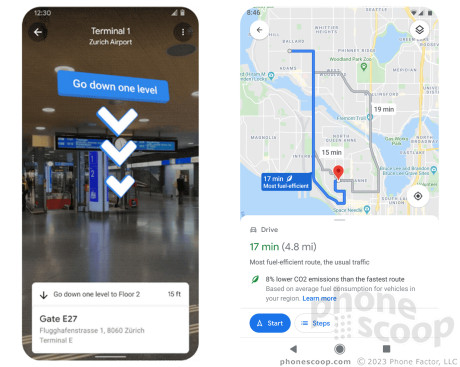
Google today announced a variety of new features for its Google Maps app. The flashiest is indoor Live View for select airports, transit stations, and malls. This augmented reality (AR) mode overlays step-by-step navigation instructions on a real-time view of your indoor surroundings via your phone's camera. The first locations supported are malls in Chicago, Long Island, Los Angeles, Newark, San Francisco, San Jose, and Seattle, followed by select airports, malls, and transit stations in Tokyo and Zurich, "with more cities on the way". The feature can help you "find the nearest elevator and escalators, your gate, platform, baggage claim, check-in counters, ticket office, restrooms, ATMs and more". Google Maps is also gaining new navigation features that take into account carbon footprint. When multiple driving routes are available, it will show which route(s) are most fuel-efficient, and by how much, as a percentage. When multiple routes have approximately the same ETA as the fastest route, it will default to the more fuel-efficient route. Maps will also now offer route options that include transit or bike without toggling between tabs.
 Motorola Refreshes razr Lineup with Better Batteries & More
 Apple Watch Series 9 Detects Finger Gestures, Brings Siri On-Device
 OnePlus' First Foldable Aims High
 Google Bringing Transit Ride History to Google Wallet
 Google Making Maps Location History Private, Even from Police

Comments
No messages

