
Google Maps Will Help You Find Lime Scooters and Bikes
Dec 13, 2018, 9:31 AM by Eric M. Zeman
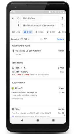
Google today announced a new partnership with Lime that hopes to help people get across the "last mile" of their journey. In 13 cities around the world, Maps will display the location of nearby Lime scooters, bikes, and e-bikes. The option to use Lime will appear under the transit icon when navigating between points. Maps will detail the closest Lime vehicle, the vehicle type, how long it will take to walk to the vehicle, how much the ride will cost, and the total journey time. Lime users can integrate their Lime card with Google Maps. Tapping on Lime in Maps will then take people to the Lime app and provide all the necessary details to book a scooter, find it, and unlock it. In the U.S., Lime scooters will be visible in Austin, Baltimore, Dallas, Indianapolis, Los Angeles, Oakland, San Antonio, San Diego, San Jose, Scottsdale, and Seattle. International cities include Auckland, New Zealand, and Brisbane, Australia. The feature is available in Maps for both Android and iOS.
 iPhone 15 Series Goes All-In on USB-C and Dynamic Island
 Cricket Launches More Affordable White-Label Phones
 Google Bringing Transit Ride History to Google Wallet
 Google Launches New "Find My Device" Network
 iOS 18 Overhauls Home Screen, Messaging, Photos


Comments
No messages

