
Google Refreshes Maps to Help Aid Navigation
Nov 15, 2017, 1:15 PM by Eric M. Zeman
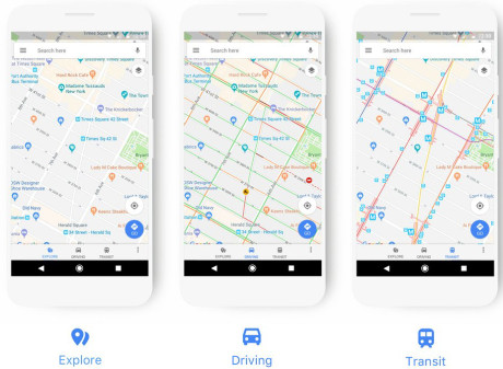
Google today announced a significant change to the appearance of Google Maps. According to Google, it has updated the look of driving, navigation, and transit maps in a way so ancillary information is more visible, such as gas stations when driving or train stations when riding the rails. Maps now relies on a new color scheme to define its legend and (hopefully) make it easier for people to differentiate between points of interest based on color alone. For example, orange signifies food and drink options, while green is for outdoor spaces, and purple is for roadside services. Google believes once people understand the color scheme, they'll be able to spot what they want or need quicker when using Google Maps. Google says this change will impact all versions of Maps (mobile, desktop), as well as other Google services that rely on Maps, such as Assistant, Search, Earth, and Android Auto. The changes will be rolled out over the next few weeks.
 iPhone 15 Series Goes All-In on USB-C and Dynamic Island
 Samsung S24 Series Adds More AI, Updates the Hardware
 Qualcomm Expands Snapdragon 8 Series to Cover More Price Points
 Motorola Refreshes razr Lineup with Better Batteries & More
 Google Bringing Transit Ride History to Google Wallet


Comments
No messages


