
Facebook to Share Real-Time Map Data with First Responders
Jun 8, 2017, 8:11 AM by Eric M. Zeman
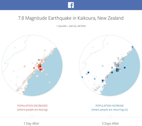
Facebook this week said it plans to provide humanitarian and other aid organizations with real-time access to its maps during natural disasters and other emergencies. According to Facebook, it will strip user identities from its map data while still showing where people are moving, where people might be marking themselves as safe, and other, similar trending information. For example, location density maps can show first responders where people are located before, during, and after a natural disaster. This can provide insight on exactly what areas are impacted. Movement maps reveal patterns of movement between cities, towns, and even neighborhoods over a period of several hours, which Facebook suggests can help aid workers predict where resources might be needed. The safety check maps provide first responders with information about where more or fewer people are checking in as safe, which can reveal the most vulnerable areas impacted by a specific event. Facebook said it will share this information with trusted organizations, including UNICEF, the International Federation of the Red Cross and Red Crescent Societies, and the World Food Programme. Facebook hopes to be able to share this information with other organizations and even governments over time. People generally provide this information to Facebook via their mobile phones.
 iPhone 15 Series Goes All-In on USB-C and Dynamic Island
 Samsung S24 Series Adds More AI, Updates the Hardware
 Samsung's New Foldables Stick to the Formula
 Google Launches New "Find My Device" Network
 Google Launches a Smartwatch for Kids
Comments
No messages


