
Google Adds Ride-Hailing Estimates to Maps
Mar 15, 2016, 11:37 AM by Eric M. Zeman
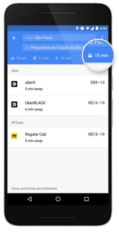
Google Maps can now tell users how quickly a taxi or Uber might take to get them from Point A to Point B, as well as offer an estimate of fares. When people search for directions from their phone, Maps will display a dedicated tab with info on ride-hailing services, such as Uber. Users will still be able to see standard car, mass transit, walking, and biking directions, too. People who have Uber or other ride-hailing apps installed on their phone will be able to see fare estimates and book with a single tap. Google says it will show multiple options from services that support them, such as Uber's UberX, UberXL, and UberBlack. While Google partnered with Uber in the U.S., it is adding 99Taxis in Brazil, Ola Cabs in India, Hailo in the U.K. and Spain, mytaxi in Germany and Spain, and Gett in the U.K. The new ride-hailing tool will reach Google Maps for Android over the next few days. Google says the the feature will reach Maps for iOS "very soon."
 iPhone 15 Series Goes All-In on USB-C and Dynamic Island
 Samsung S24 Series Adds More AI, Updates the Hardware
 Google Bringing Transit Ride History to Google Wallet
 Android Auto Will Know Your EV's Battery Level
 Pixel 8 Phones Gain Circle to Search, Thermometer, and new Mint Color


Comments

I need speed limits